


Jim told me that, standing up on top of the hills where he took this pic, he could hear the desperate cry of hikers that had ventured down to the valley floors and gotten lost in the natural rock maze. Plus the occasional scream as one would get eaten by a Griffindor…
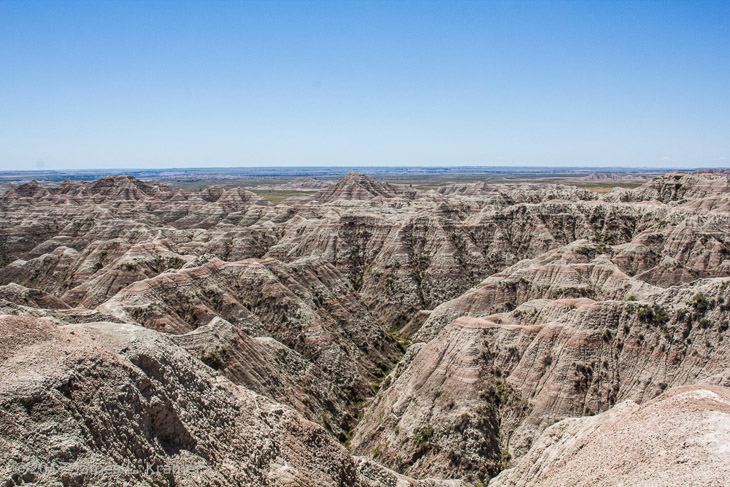
Okay, I lie, Jim would pay no attention to anyone that idiotic. But I did finally look up the geologic history of the Badlands, and found that it’s a lot softer than I imagined (as Jim mentioned in a corrective comment on a previous post.) The area is all sedimentary rock, which the distinctive layers indicate, but weak stuff, not like shale or slate. Somewhere around the time the dinosaurs were leaving the neighborhood, this was the washout region from the Rocky Mountains, receiving the settling sediments from the erosion of those mountains, as well as a few layers of volcanic ash, yet there wasn’t enough accumulation to build up the weight that would fuse the layers into tougher rock. Before this could happen the entire region was uplifted, which then meant that water was running off of it rather than pooling over it, and the valleys started to form through what was once lake or ocean bottom. With bigger hills nearby, this area would have eroded away entirely by now, but since it’s still largely flat the runoff generally comes from rain, which isn’t as destructive as, say, rivers and glacial meltwater. Nonetheless, the region is said to lose 2-3cm (about an inch) in height each year, which is pretty fast as far as erosion goes.
So the lost hikers only have to bide their time, and the maze will drop low enough to see their way out easily. No biggie.
I find what is so incredibly strikingly in this area is the “hills” just pop up out of this utterly flat land. All of the green areas are at the same elevation, and it’s just completely flat until these mountains arise.