


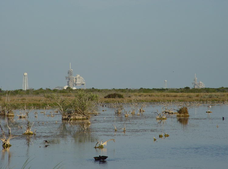
This week, the folder selection for our archive digital shots is ‘Space.’ If you’re viewing this image and thinking it doesn’t look very spacey, well, how you could be so ignorant? Look again, you oblivious savage. Those structures are launch pads 39-A and 39-B at the Kennedy Space Center at Cape Canaveral, the very places where every space shuttle mission, and for that matter every Apollo mission, began. If you’re on your way to the moon, this is where you board.
The photo was taken from Playalinda Beach Road on Merritt Island, which is where the Cape is located – it’s no surprise that this is right outside the property of the space center, and in fact this region was always closed off during launches (and I think landings as well, since the Canaveral Skid Pad, the landing strip for the shuttle, sits about 5 kilometers off to the right of where this picture was taken.) The nearest pad, to the left, is 39-B and is less than 5 km distant, while 39-A on the right side is a little over 7 km off. The Vehicle Assembly Building is well out of the frame to the right, but was still plainly visible from this location – and in fact, is plainly visible from just about anyplace in this region of Florida, due to its own height and the flatness of the land.
The kind of triangular/semicircular portion of those launch gantries was the payload section, which was hinged and would fold closed over the shuttles after they reached the launch pads. The water towers nearby were solely for use during launches, flooding the pads with water as noise and vibration suppression – if you look at any photo or video of the shuttle launches, the huge clouds of white smoke that you see aren’t smoke, but water vapor from this water – the rocket exhausts were either darker, for the solid rocket boosters, or virtually nonexistent for the shuttle main engines. And I’m speaking in the past tense here because these launch gantries no longer exist – they’ve been taken down and rebuilt, with SpaceX using pad 39-A for the Falcon launches and 39-B being refitted for the new Space Launch System.
The foreground, unsurprisingly, is swamp, with a few birds visible here and there; most of the Cape is wetlands, and I recall reading an article by one of the people tasked with finding a location for the nascent space program, back in the 1950s. His reaction to this proposed location was almost of horror, and he distinctly recommended against this boggy, alligator-infested, mosquito-breeding-capital of a candidate – it seems his vote was discounted (there were other mitigating factors, some of which I’ll be happy to relate if anyone asks.) Even after the decades of development by NASA and the USAF, the region is still boggy and alligator-infested, but enough dry land was discovered/created to prevent launch vehicles from disappearing into the marsh. Seriously, check it out on Google Earth or the aerial photo service of choice. It’s a cool place for wildlife photography, especially Merritt Island National Wildlife Refuge only a few kilometers from this point.
A little trivia. This photo was taken in May 2004, a little over a year since the Columbia had broken up on re-entry over Texas, and the pads were sitting dormant while the program was in examination. On the day of the accident, I was actually driving up to within visual distance of the landing strip and realized that I should have checked the timetable – I might have been able to see the landing while I was there. The accident occurred while I was in the car, and I heard about it as soon as I arrived. And just to give you an idea of the velocity of the incoming shuttles, that mission was due to touch down at 9:16 AM in Florida, but broke up at 9:00 AM over Texas and Louisiana while traveling approximately 21,000 kilometers per hour (13,000 mph.) Touchdown speed for the shuttle was about 330 kph, so all of that speed had to be shed in that timeframe.
By the way, if you look up the area on Google Earth, slide westward over to the landing strip (it will be abundantly obvious) and the service road that runs from the southern end of it, then roll the date back to March 1994 – you can see a shuttle being towed from the Skid Pad back to the Vehicle Assembly Building. That would be STS-62, Columbia itself, having just returned earlier that day from its mission.