


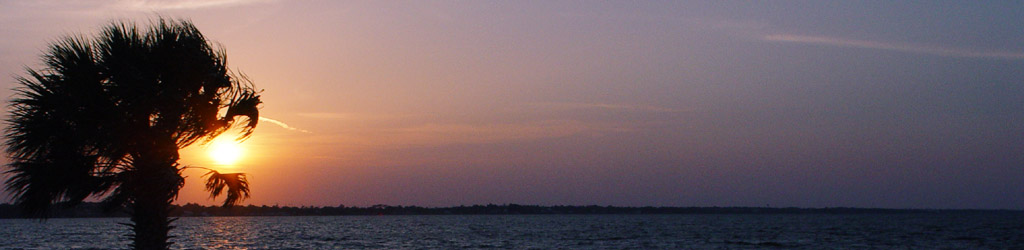


For the Sunday slide entry two weeks ago, I mentioned that I might be back “in a few days” to elaborate on another aspect of the shot. I figure I might as well bring it up now before the original gets pushed below the ten post limit I set for the main page.
The image had originally appeared to illustrate a “middle of nowhere” post some years back, which I think it does nicely. So much of photography, however, is just as much about what you don’t show as what you do, and in this case, the viewer has no impression that a high-rise resort hotel sat only a few hundred meters behind where I was standing for the shot. Granted, it was down at the end of the road on the barrier island, the last little bit of ‘civilization’ before empty dunes and marshes, but this was Wrightsville Beach east of Wilmington, NC, which is much more developed than I prefer, and certainly more than the photo indicates. If you like, this link will take you right there if you have Google Earth installed, or you can enter “34.237377 N 77.776623 W” in the mapping service of your choice.
I always have misgivings about revealing ‘secrets’ about photos, because the primary appeal of images is what you see, not what was real – I especially don’t like taking a chance of ruining an impression. But I also find value in teaching people how this works and how to be particular about their scenes and framing, so I’ll sacrifice an impression for the greater good. Or something like that – I can make it sound even more dramatic if you like. Regardless, it wasn’t exactly the middle of nowhere, but I’m fine with calling it the edge of nowhere if accuracy is important – very desolate if you faced in one direction, not very isolated if you turned around. And far enough from the really developed areas not to have traffic or construction noise and all that ‘civilized’ rot.
As I was mentally framing this post, I started wondering where my most isolated photos had been taken, ever. And came to the conclusion, pretty quickly, that none of them were all that isolated; I’ve never done long hikes out into the wilderness to find that remote locale, and while I don’t mind exploring, there’s a certain risk to venturing out alone a long ways away from, for instance, ambulance access and fresh water and all that. It might produce some unique photos, true – and it might not. I’m usually not struggling to find something to photograph with even short hikes out into the woods or down the beach, so the amount that I’ve been “out there” is minimal, really.
Right now, I’m pretty sure I know the remotest location, and again, it’s not that impressive, but it’s still noteworthy. Back in 1999 or 2000 (the processing lab that I used at the time did not print the date on the slide mounts,) I took a ‘business’ trip out to Portsmouth Island, one of the barrier islands on the coast of NC between Ocracoke Island and the Cape Lookout/Beaufort area. It was ostensibly a fishing trip, though for most of the guys I traveled with this translated to drinking like fish, and very little angling was done. I don’t drink, and I was planning on getting up before sunrise, so the evening was rather tedious for me. Portsmouth is a largely undeveloped island, though, with only a handful of buildings, mostly rental cabins, and no roads whatsoever; access is by ferry, and you’re only allowed onto the island if you have a four-wheel-drive vehicle that can handle the sand – we rented one for the occasion. There wasn’t even electricity, so cabin lights and heat were provided by propane, and food was kept in coolers and maintained with ice deliveries by daily ferry – lettuce, as I was to discover, doesn’t like being kept in a cooler full of ice.
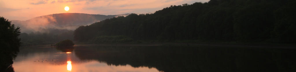
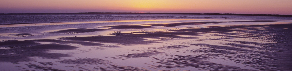
The second evening that we were there, the sky cleared and we drove down the strand a ways to the end of the island, where some of the guys actually started fishing (spending about 1/10th the amount of time doing this that they had drinking the night before,) while I tooled around looking for photos. Overall, I shot maybe two rolls of 36 exposures on the entire trip, probably less – that’s not a photo trip, as far as I’m concerned, but some of that was due to bad weather rolling in the evening we arrived. Nonetheless, I have some nice keepers from the trip, including two images in the main gallery, one here and the other linked from that page. And of course, there is a Google Earth placemark on both, but it’s the same one so clicking only once is enough. Or use “34.855740° N 76.316729° W”
Technically, the photo location is only about 3.5 kilometers (2.25 miles) from the nearest road, which would not be considered an arduous hike except that this is measuring directly across Core Sound, and if you can hike that, more power to you – it was farther than that up the island to the cabin where we were staying. And to get there, we had to take the ferry up and around the tidal shallows, so the actual path was 14 kilometers (8.75 miles,) half of that by boat. Granted, most of it was still spent in the truck – I wasn’t enduring any hardships getting there.
But now it gets interesting. This link (34.898682° N 76.257028° W) is the ferry access, just northeast of the cabins, and if you compare the two locations, you’ll notice they’re not even on the same island. They were, back at the turn of the century (I love saying that,) but barrier islands are like that, subject to radical reshaping by storms. A few years after our visit, a new channel cut across the island, while the channel that I shot those photos alongside filled in and joined another island farther southwest. The Immobile Mr Bugg had said that he wanted to visit the island to shoot from the same location, but he actually can’t since it technically doesn’t exist anymore.
[I’ll take this opportunity to mention the same thing that I’ve told him: while some locations are photogenic, most times, it’s not the location that’s the key to a great photo, but the conditions – with the right light and sky and grasses and all that, many locations might provide a lovely scenic shot, but you have to recognize and exploit the conditions when they come together, and often this is subject to the vagaries of the weather, not to mention your skill as a photographer. Hiking out to the same spot Ansel Adams shot from doesn’t mean you’re going to get his images.]
This is where using Google Earth is more interesting, because you can roll the dates back and see the aerial images from earlier, watching the island reshape itself – it’s pretty dramatic for that particular area (I wouldn’t recommend buying property there.) And this brings us back to the original location from the Sunday slide post, the marsh channels off of Wrightsville Beach. Back in 1992, I had trekked a short ways off of that loop at the end of the road, up past the hotel, and had camped on the sand dunes, having a pretty miserable night from the summer heat. In trying to get some breeze into the tent I had left the rain flaps open, but screens aren’t adequate to stop blowing sand, which was often carried into the tent with every gust to adhere to my bare and sweaty chest – I’ve had better nights. A couple of years later I revisited the area and out of curiosity intended to go back to the general spot where I’d camped, but was stopped quite distinctly by the fact that it was under at least two meters of water by then – a storm in the intervening time had gouged a channel through the island right where I’d been sleeping fitfully. You can roll this back in Google Earth too, any date from 2002 and earlier, and after that you can even see the planted beach grasses to stabilize the dune and hopefully prevent the water from coming as close as it did to the hotel. I imagine the insurance rates for the building are astronomical.
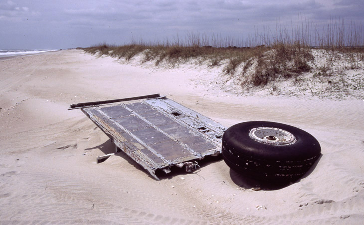
Just a small aside here. This image was also taken during that trip, obviously aircraft parts, but I have no information on how they arrived there – one beach wreck survey that I came across speculated on them washing ashore from an artificial reef, ones usually created by sinking derelict ships, but I don’t imagine aircraft parts are the material of choice in such a turbulent coastal area. There has always been a lot of military activity in the region, including a small airfield just inland, so there are a lot of ways this could have arrived. I found it a curious little tableau, myself.